
Our dear friend Margaret has a unique skill. Whenever she comes up, we see lots of wildlife—without fail. This time was no different, just, um...better.

Adventures from Arizona to Alberta
Viewing entries tagged
day hike
Our dear friend Margaret has a unique skill. Whenever she comes up, we see lots of wildlife—without fail. This time was no different, just, um...better.
Dave and I always thought that Mount Yamnuska was for climbers/scramblers only. We were mistaken. Let me tell you—this hike was the best discovery of our entire summer.
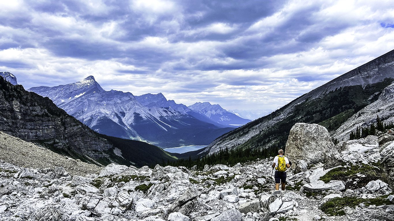
At times, selective memory can come in handy. In hindsight, we, as humans, tend to block out certain realities while focusing on the overall experience. I find this selectiveness enormously helpful when revisiting a “favorite” hike.
I’m referring to Sparrowhawk Tarns—a relatively short (11.6km/ 7.2 mi) but steep (700m/2,283 ft) climb through a land of fossils and marmots—that takes you to a spectacular view of small lakes, meadows, and surrounding mountains.

View of Sparrowhawk Mountain from the trail.
The day was ours to enjoy with turkey sandwiches, lots of water, and bug spray in tow. Our early start almost guaranteed minimal dust from Spray Lake Road—which came in handy for wildlife sightings.
The trail began on the High Rockies connector trail, leading to a junction for Sparrowhawk (left) and the High Rockies Trail (right).

High Rockies continues on right, Sparrowhawk straight ahead.
About 30 minutes into the hike, we heard a couple below us making their presence known to any bear within at least five miles (hahaha). Lo and behold—we know these people! What were the odds that we would run into our neighbors Corey and Willis on the same trail simultaneously? Pretty slim. Great minds think alike.

Willis and Corey with Maggie leading the way.
Excellent company and conversation took us past a lovely little stream, where Maggie took a quick dip.

We parted ways at the treeline—after taking a moment to photograph a nearby whistling marmot.

Rocky climb begins here.

Marmot
Enter selective memory. Our climb involved a never-ending pile of boulders, following multiple paths leading to points unknown. Let’s say there are many ways to get to the top, and thankfully, the actual trail is much more apparent on the way down.


But the view is worth the effort.

Alpine meadows.

Small lake view from our lunch site.

The trip back was steep, somewhat precarious, and not at all leisurely. Nonetheless, it was a heck of a lot faster than the climb.
Dave making his way down, with Spray Lake in the distance.
Later that evening, Corey texted a photo she took of Maggie and Willis that captured the spirit of the day—serendipitous.

Maggie and Willis in the alpine meadow.
Dave and I have a knack for turning an easy outing into something a little more challenging. Ask anyone (yep, you, Margaret) who has hiked with us—every trip is an adventure. Hey, it doesn’t matter if it’s a quiet walk around Canmore—take a few trail detours, and three miles can quickly turn to six.

Warspite Creek.
We were looking for a simple, scenic hike to spend a Sunday afternoon. Warspite Lake via Black Prince Cirque Interpretive checked all the boxes: easy, short, and beautiful. The out and back route was just over four miles with an elevation gain of 700 ft (220 m). A lovely, soft-padded walk through a lush spruce forest. What on earth could go astray?


Trail just before the lake.
Once at the lake, we opted to follow the trail around the lake counterclockwise to take photos and escape people milling around the entrance.

Warspite Lake
There were still frozen areas near the shoreline—unusual for late June in Kananaskis.

Lake ice.

Mount Black Prince, and Warspite, with Haig Glacier in the background.
Before long, Dave and I noticed a group who had passed us earlier was heading back. Soon after, we encountered a family trying to cross a rushing stream covered with downed trees. Dad scrambled his way across the logs to the far bank while Mom stood up to her knees in the icy water. Their kids stood silently—apparently wanting no part of it.

Nothing clear-cut here.
As Dave surveyed the situation, the parents retreated. The six-year-old glanced at her parents and then at us, exclaiming, ”This crossing is definitely for the young, nimble, and light of foot.”
Duly noted—and ignored. Dave deftly made his way across while I lumbered my way through the icy water.

No trail here.
Bushwhacking our way around the lake on a nonexistent trail covered with debris, fallen logs, and water was a bit unnerving initially but ultimately satisfying.

Bushwacking.
Once through the bog, the lakeshore became easier to navigate. The craggy white rocks surrounding this portion of the lake hosted several family picnics.

Heading back, we crossed paths with an outgoing spruce grouse.

It was an excellent way to spend a Sunday afternoon—detours included.
“The Crack” at Wet Beaver Creek—seriously? It’s hard to imagine a smuttier name for such a beautiful place. Who comes up with this stuff? I suppose it was named in a simpler time, a time when words had more literal meaning. Or—maybe someone just wanted a laugh.
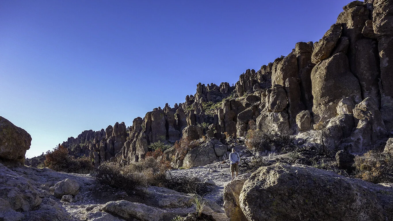
Wow—I had no idea. Where has this gem been hiding? If you can get there to see the sunrise—do it. Peralta Trail to Fremont Saddle is a mesmerizing, challenging hike with a dramatic reveal.
The Superstition Wilderness in Gold Canyon offers many hiking opportunities. It is hard to believe that these towering hoodoos are the product of over 20 million years of erosion.

We arrived before dawn, and it was COLD and WINDY. Although dressed in layers, we wore shorts, which initially was quite unfortunate. Dave and I sat quietly in the jeep, toasting ourselves before venturing outside. We hit the trail at first light.

Rocky road.

Frankly, I don’t remember much of our adventure’s very beginning—we were too busy trying to warm up. Eventually, we stopped and took a look around. Massive columns of volcanic rock enveloped us as the sun broke over distant peaks. Phenomenal.


The roundtrip is a rocky 5.8 miles, with a total elevation gain of 1,330 ft. Allow at least four hours (more or less) to navigate the rocky terrain and soak in the beauty of the canyon.

Morning light.

Dave and I wound our way to the saddle’s base, where the real climb began. Switchbacks led to a smooth granite pass scattered with large boulders—a perfect place to grab a snack and pull out the iPhone. Splendiferous.

Smooth granite slabs (lower right), made the ascent easier.

Looking back from the saddle.
The pièce de résistance awaited at the saddle—Weaver’s Needle. This spire of fused volcanic ash rose from the valley below. A large remnant formed from over 20 million years of erosion, it climbs a thousand feet from the desert floor, with a summit of 4,555 feet. Rumors have it that the needle’s shadow casts the location of a cache of gold—part of the lore of the Superstitions.

Surprise!
Fremont Saddle.
By the time we made it down the rocky path to the parking lot, the lot was full. Even though the sun’s glare took some of the magic away, and our ankles and feet were stiff and sore, a brief scroll through our photos made us realize just how memorable this hike was.
Finally, it happened. After 110+ days of drought and intense heat, it RAINED. Not just a smattering of drops that move dust around—a lovely, rushing deluge. A much-needed cleaning of air, soil, and spirit.

Dark shadows and sunlight.
The next morning under clearing skies, Dave, Margaret, and I celebrated by hiking Tom’s Thumb Trail, located in the McDowell Sonoran Preserve. We started around 9 am—blissfully chilly through the first part of the hike. Layers were the key to comfort.

View from the beginning of the trail.
The trail is a steep one (1,200+ ft in elevation), but don’t let that stop you. There are plenty of waypoints to take a break and catch your breath while admiring the beauty surrounding you. The first mile is the hardest, but once you get to the first ridge, it becomes more moderate.

On our way up.

On our way to the Thumb.
After heavy rain, one would think that the trail would be muddy. Not in Arizona. The path, washed of small pebbles and dust, made the ascent and descent so much easier.

The Land before Time.

Tom’s Thumb.
Air, lightly scented with fresh creosote, combined with smogless skies, made the trip extra special. We snacked upon well-deserved clementines and molasses cookies before heading down.
Days like these are one in 110+.

Glistening saguaro.
Memories of Yukon Cornelius come to mind when I think of Dixie Mine—a whole lot of nuthin’. However, the checkered past and expansive views it provided made the trip worthwhile.
Just minutes southeast of Flagstaff lies a lovely little trail that shows a different take on Walnut Canyon. Petrified sand dunes, canyon gorges, and caves—what a combination.
For many, Sedona is the place to be. This little town is a haven for hikers, mountain bikers, art collectors, and spiritual advisors. It can also be pretty congested. However, a little patience and timing can pay off in a big way.
In the desert, one can see forever. From almost every vantage point in Phoenix, the iconic Four Peaks come into view. During winter, the peaks are often snow-capped, providing a glimpse of seasonal splendor from our sunny confines.
This is our summer of Kananaskis. We have intentionally avoided the hotspots in Banff National Park to focus on hikes that are much less crowded and every bit as beautiful. Our travel time is a bit longer but well worth the effort.
This was our second attempt to hike Ptarmigan Cirque and I am thankful to report that this time, there was very little snow to contend with. After a cold, wet and rainy June, summer decided to finally appear for more than a day or two. The sun finally came out, and so did the people.
Headwall Lake is usually a forgotten hike. It shares the parking lot with the premier Chester Lake trail and doesn’t get star billing. In fact, it gets no billing. Push those thoughts aside—this 10-mile hike weaves through multiple terrain, on its way up to some pretty spectacular views.
“In this world of ours, the sparrow must live like a hawk if he is to fly at all”—Hayao Miyazaki
Well, then. That’s a tall order. I find similarities between that quote and hiking. If one never learns to climb, then one may never experience the view from the top. OK, let me put that in context. Once in a while, it is important to challenge yourself.
Chester Lake was closed due to bear activity. Argh. Why didn’t we check the Park’s trail website before we left? Now what?
After an hour-long ride up Spray Lake Road, we were done with driving. What we needed was a Plan B. As luck would have it there was a B—as in Burstall Pass, just across the road. So, Plan B it was.
Mud Lake
The trail took us up an old logging road through forests and lakes to an alluvian meadow. Rivulets of water threaded throughout the terrain. as we made our way across the wet, muddy soil. Surrounded by mountains, we were captivated by Robertson Glacier as we tried in vain to keep our feet dry.
Alluvian meadow
Robertson Glacier
About 4 miles in we started our ascent. The dense forest trail opened up into an beautiful alpine meadow, filled with wildflowers and young spruce. I spotted a familiar track on the trail, which looked disturbingly kind of fresh. No worries, hahahaha. Ha, umm.
We hiked through patches of snow up to the headwall and were rewarded with mountain views in all directions. The expanse was humbling.
Windy and chilly, we tucked into a small island of trees to enjoy our sandwiches. Burstall Pass now ranks as one of our all-time favorite hikes. Not bad for a Plan B.
View from the pass.
Our friend Margaret is not a morning person by nature. But it is summer in the Canadian Rockies, and the true beauty of Lake Louise is best shared early. Really early.
We were up at 5:30 a.m. for a 6:30 a.m. departure. Our forecast was for partly cloudy skies with scattered showers possible.
The road to Lake Louise
We arrived around 7:30 a.m. and found parking easily. A steady, pelting rain greeted us. Undaunted, we bundled up in layers with raincoats and hiking poles and set out for the Plain of Six Glaciers teahouse. The rain created jewel-like images that were nothing short of magical.
Lake Louise Lake Trail
Lake Louise
Looking back, with the Fairmont in the distance.
Where fresh water meets glacier melt.
The rain turned to drizzle as we started our ascent. The trail was essentially ours alone. Glaciers surrounded us. We made a steady climb through woods and scree. Part of the trail was out due to water, so we adventurously bypassed it on steep terrain. Awesome.
Lake Louise from the trail.
A very happy Margaret
Photo break. Plain of Six Glaciers trail, Lake Louise, Banff National Park.
We reached the top and enjoyed the Teahouse's famous chocolate cake and tea. A short trek to view the glaciers was followed, along with some scary stories about Pole Glacier, a.k.a. the Death Trap. Fun.
Dave and I descending into chaos.
Mountain solitude met high tourist season on the way down. But, we were content. Not only did we conquer mountains, we conquered CROWDS.
The Chester Lake Trail is one of my Dad’s all-time favorite hikes. He has been hiking this trail for close to 30 years—and has introduced it to many friends and family members. It is a moderate 10.6 km out and back hike with views rivaling anything you will see in a National Park. The first half of the hike is a steady incline, followed by a beautiful meandering trail through lush green meadows. When hiking around the lake, we often take a detour to a place we call Elephant Rock. It is a short, unmarked trail that leads to some enormous boulders worthy of exploring.
In the spring there is an abundance of wildflowers, and in the fall, golden stands of larches. For an entirely different experience, many snowshoe during the winter months on the well-marked trail.
We hike to the lake at least twice during the year. The trail is closed from May 1 - June 29 for wildlife passage. And it can also be closed when a grizzly decides to visit. So, pack a lunch and spend a day in the wilderness. You won’t be disappointed.


Chester Lake Trail, Peter Loughheed Provincial Park.

Spring wildflowers, Chester Lake, Peter Loughheed Provincial Park.

Beauty on the trail.

Lakeside. Chester Lake, Peter Loughheed Provincial Park


Alpine clarity, lakeside.

View from the lakeside portion of the trail. Chester Lake, Peter Loughheed Provincial Park

“Elephant” Rocks

Hillary and Bruno on the rocks.


Our favorite lunch spot, on our own private island.
The warmer it gets in Arizona, the more I begin to dream about Alberta. There is nothing quite as special as hike in early June to the Lake Agnes Tea House, at Lake Louise.


