
This is our summer of Kananaskis. We have intentionally avoided the hotspots in Banff National Park to focus on hikes that are much less crowded and every bit as beautiful. Our travel time is a bit longer but well worth the effort.

Adventures from Arizona to Alberta
Viewing entries in
Alberta
This is our summer of Kananaskis. We have intentionally avoided the hotspots in Banff National Park to focus on hikes that are much less crowded and every bit as beautiful. Our travel time is a bit longer but well worth the effort.
Dave and I love the Dorrien Smith/Spray Lake Trail. We love to take our friends up the narrow, unpaved road, through all its twists, turns, and drop-offs—just to scare the crap out of them. You can always tell if someone has been there by their white, dust-encrusted vehicle. A right of passage, at least until the next rain.
This was our second attempt to hike Ptarmigan Cirque and I am thankful to report that this time, there was very little snow to contend with. After a cold, wet and rainy June, summer decided to finally appear for more than a day or two. The sun finally came out, and so did the people.
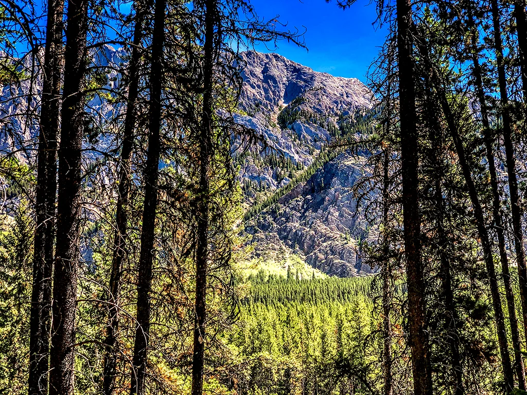
Headwall Lake is usually a forgotten hike. It shares the parking lot with the premier Chester Lake trail and doesn’t get star billing. In fact, it gets no billing. Push those thoughts aside—this 10-mile hike weaves through multiple terrain, on its way up to some pretty spectacular views.
Our reason behind hiking Taylor Lake was simple. There was a connection. You see, Dave’s Mom’s maiden name was Taylor. The name alone rekindled wonderful memories for him—even before our hike began.
Canada Day in Canmore is a joyous event. Every year, the town swells from 14,000 to well over 20,000. On July 1st, families crowd the streets to view marching bands, campy floats, olympic athletes on ski-skates and Calgary Stampede dignitaries. Squirt guns are almost mandatory. This year, we decided to change it up.
This year, the longest day was truly the longest day. Summer solstice sans summer. But the week of rain and high country snow eventually gave way to sunshine. And, the remaining stretch of Highway 40 in Kananaskis had opened, providing us with the opportunity to hike Ptarmigan Cirque.
It was spur of the moment. Dave and I hastily made a couple sandwiches, threw the bear spray in the Jeep and headed out. Little did we know what we would actually find.

On our way to the cirque!

After a beautiful start up the mountain, we climbed into some thick clouds still remaining from the previous day’s rain. Fog as thick as peanut butter (hahahaha)—made it necessary to turn on fog lights and slow to a snail’s pace. What began as patchy snow became a blanket, reminiscent of early fall in the Rockies.


And then the sun broke through.

Just outside the parking lot at Ptarmigan Cirque Trail.
By the time we reached the cirque, it became apparent that there was to be no hiking today. The snow was close to a foot deep, and our boots were not waterproof.

Fresh snowfall.

You know, all in all, It didn't seem to matter. I had never seen the upper portion of the Kananaskis trail and it was quite magical.

Ptarmigan Cirque can wait. :)
Opportunities are like sunrises. If you wait too long, you miss them.—William Arthur Ward
Our reason for hiking the Grassi Lakes circuit was two-fold. A family of owls was known to be nesting in the cliffs above the lake and it was a beautiful day. With that in mind, Dave loaded up his camera gear and we set off on a photo safari.

Lower Grassi Lake
If there is one hike that appeals to all ages and levels of endurance, Grassi Lakes is it. The trail is about 2.7 miles roundtrip and offers an easy path (service road) and a not so easy path (along the edge) to the top. The lakes, waterfalls and a nearby mountain was named after Italian immigrant Lawrence Grassi—a miner, hiker, climber and master trail-builder. The trail was built by Grassi back in 1918, during a miner’s strike. He went on to build the Oesa trail at Lake O’Hara along with many others. A solitary man, he lived in an ivy-covered cabin by the Grassi trailhead, until his move to Bow Valley Regional Housing, where he lived to the ripe old age of 90.

Lower Grassi Lake.

As with most hikes around here, It pays to be early. We had both lakes mostly to ourselves for at least 45 minutes.

Lower Grassi Lake.
This hike never gets old. Reflections and jewel-like hues were magnified by the early morning light. The clarity was amazing. So much color in such an attainable venue—I can see why Grassi loved it so.

Upper Grassi Lake, looking for owls.

Nothing here but rocks…..
We headed to the upper lake was where the owls nest was located—a craggy cave nestled a steep rock face. Dave swiftly set up the camera and try-pod. He zoomed in and….NOTHING. Wait, wasn’t that the owl on the side of the cave? Nope, it was a ROCK. Dang. Our neighbors had seen them the week before, but for us, it was not to be.

We shrugged it off and continued down the mountain on the cliff side. This was Grassi’s original trail, consisting of steep stairways, flowing creeks, large smooth boulders and spectacular views..


We crept out on a narrow pathway off the main trail to get a closer look of the falls. So worth it.

We may have missed the owls that day, but that only gives us another reason to return.

Homeward bound.
“We love the things we love for what they are.” ― Robert Frost
Sometimes a hike is just a long walk in the woods. Many hikers tend to pass on hikes that don’t reward them with wide open spaces, memorable vistas and physical challenges. I get that. But sometimes, the solitude and quiet of a less travelled path can be quite lovely.

Pocaterra Trail was one of those paths. The trail is a gentle upward climb through the woods, with glimpses of creeks, small lakes and mountains.

Pocaterra Creek.
We were completely alone that morning. The forest floor was damp and soft from the recent snow. Our first detour was to Pocaterra Creek, which we accessed following a game trail. Still in search of that elusive moose…

A sea of fern appeared, captured in early morning sunlight. Another brief scramble took us down to Rockwall lake, it’s muddy bottom covered with elk tracks.

Rockwall Lake.

As we climbed up the ridge, the mountains came into view; below us, lush green meadows.

The trail was wide enough to walk side by side, and easy enough to hold a conversation. Dave and I solved many of the world’s problems that day (hahahaha).
At one point we went off trail in search of Sparrow’s Lake. After foraging uphill through a mass of deadwood and moss we came upon a small meadow. A quick look at the map indicated that we would have to cross multiple ridges to get to the lake. That was not gonna happen. There was no real access from our route.

Strange and creepy mushrooms.
Oh—lest I forget, we saw some pretty weird mushrooms along the way, popping up under pine needles. I do not believe they are edible.
We were about three and half miles in when we realized our sandwiches were still on the counter at home. It was definitely time to head back.
Our favorite trails will open soon. The quiet and solitude will soon be replaced by an onslaught of tourists. But for a brief moment in early June, a quiet walk in the woods gave us both time to just be.
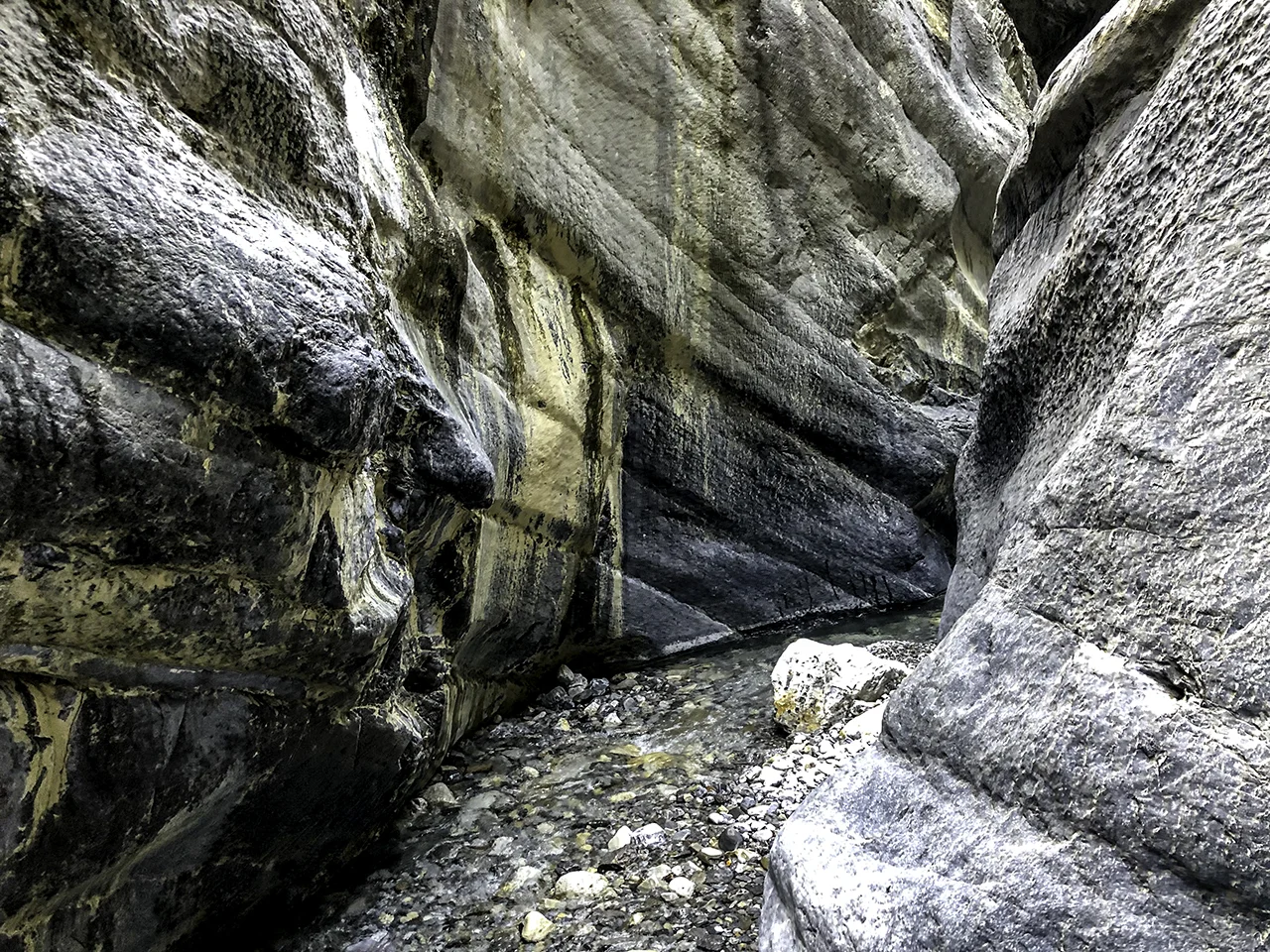
I wouldn’t call Jura Creek a hike—I’d call it an adventure. Located by the Baymag plant on Highway 1A, the trailhead is far from ostentatious. In fact, it’s practically non-existent—the official site is currently under construction. That aside, Dave and I were pleasantly surprised. The real fun began about a quarter mile in at the mouth of the slot canyon.

The mouth of the canyon
This hike was more like an obstacle course through flowing water—consisting of scaling boulders, crossing deep pools on single logs and stepping cautiously from rock to rock. About a mile in, it became apparent to Dave and I that dry feet were not gonna happen.


A smooth piece of Jasper in the creek.
Jura creek was robust, thanks to recent snowmelt. We made our way through a maze of deep, narrow passageways, filled with pools and mini waterfalls. The high walls were cold and damp with sunlight just starting to find it’s way through the opening. Exquisite.

The canyon opened up into a large, rocky creek bed. As we progressed, the creek dried up and the hiking became a little tedious. It did however, give us plenty of time for our feet to dry.

Canyon’s end, nearing the creek bed.
Eventually, we came upon a huge headwall. Dave and I looked at each other, both wondering if we should try to scale it. Hmmm. On the right, super smooth stone that was pretty vertical. To the left, a wall of rock with a v-like formation. A stream of water was flowing down the center. Others have done this—right? Don’t we want to see what’s up there? What the heck. We chose the V.

To the top of the headwall.
In hindsight, it looked a lot harder to climb than it actually was. At the top were a series of pools captured in smooth white stone. We gazed down into deep crevices where the creek graced us with it’s reappearance.


Peering into the cracks.
The trail turned into a creek bed once more. For us, it was the perfect turn-around point. Our return trip was not nearly as graceful. I guess it never really is. We sloshed back through the running creek with reckless abandon, the canyon then filled with sunlight and warmth.
Jura Creek is a well-hidden gem. Selfishly, we both kinda hope it stays that way.
Well, our first couple of weeks in Canmore have been interesting. Any schedule that previously existed was promptly thrown out the window. Especially at night. Luci took a few days to adjust to her new surroundings, and Dota is still adjusting to her new sister. It might take years. Everything around here happens at warp speed—until it doesn’t. Luci reminds me of the Honeybadger, a former LSU and Arizona Cardinal cornerback. She will knock off anything that gets in her way. She actually bounces. All kidding aside, Lucia is a welcome addition.

Sunday morning - before the hike.
With that said, Dave and I left the pups and ventured out for our first hike last week. Elk Pass to Frozen Lake is an 8.4 mile out and back trail located by Lower Kananaskis Lake. The trail, an old fire road, eventually leads to Elk Lakes Cabin (maintained by the Alpine Club of Canada) and a backcountry campground.

It was about an hours drive from our place to the trailhead. The weather was cloudy and a chilly 45°. Our trek started off blissfully snow-free and dry. However, as we gained elevation, the dry trail turned to ice and snow—slowing our pace considerably.

What happened to the trail?

Fox Creek. No sign of moose.
We crossed multiple bridges, following some giant moose tracks in hopes of a sighting.

The Kananaskis range is daunting and massive. There were some impressive views to be had along the way.
Icy meadow. No sign of moose.
As the day progressed, the snow turned into slush. By the time we reached the meadow, it was a real mud-fest. We were about 3.5 miles in when we decided to have a bite to eat and head back.

Wildflowers blooming out of the bog.
Tired and cold, we were still content. For the first hike of the season, it was a splendid way to get our feet (soaking) wet.
I would be remiss if I didn't cover this adventure in October.

Bob and Linda Carey
According to the Breast Cancer Foundation, there will be an estimated 266,120 new cases of invasive breast cancer diagnosed in women and 2,550 cases diagnosed in men in the U.S. in 2018. An estimated 41,400 breast cancer deaths will occur.
Our friends, Bob and Linda Carey are no strangers to these statistics. In 2003, Linda was diagnosed with breast cancer. She beat it, only to have it recur in 2006. Bob had lost his mom to breast cancer years earlier, and knew full well the battle they were up against. Bob, a professional commercial photographer, created a series of self-portraits donning a tutu, conceptualized during a shoot for Ballet Arizona. He shared the images with Linda, which resulted in some much needed laughter. Linda shared the images with other breast cancer patients during treatment and the rest is history. The photos went viral. In 2016. The Tutu Project was officially created. Linda is a now a 15-year breast cancer survivor, and an inspiration to all of us.
The Adventure: Last August, Bob came up to Canada to visit Dave and I in search of locations for some new tutu photos. Our daily road trips consisted of scouting for the perfect backdrop for the quintessential tutu shot. We found some despite the heavy smoke that filled the air, from multiple fires that covered Alberta and B.C. The thick haze and freaky orange glow added a sense of drama to the photos that was truly unique.
Kootenay River, British Columbia
A drought had nearly emptied Goat Pond. It looked dry, but it was incredibly muddy. Dave was worried that a rescue might be in order. Nothing (and I mean NOTHING), stops Bob from getting the shot he wants.
Late one evening, we visited Moraine Lake and Lake Louise to shoot and had quite a few tourists from Germany and Japan recognize Bob, who then graciously posed for selfies with them.
Moraine Lake, camera view.
Tutu at Lake Louise, Banff National Park
Our visit was filled with great conversation, laughter, and a lot of love. Dave introduced Bob to poutine, which quickly became his food of choice. Espresso the cat left a little gift in his suitcase. What a fiasco. All in all, a quick but successful three days of road trips and photographs. What a wonderful way to bring some joy and laughter into people’s lives in a most unusual way.
The Carey Foundation, a breast cancer non-profit was established to provide everything from financial assistance to emotional healing. They are global, reaching over 250,000 supporters worldwide. To find out more about The Carey Foundation or to make a donation please visit thetututproject.com
Now, where was I? Oh yes, the spruce grouse… Later that evening, it became abundantly clear to me why they were so darn busy.

Good Morning.
I know I am being more than a little dramatic. It’s not that unusual for Canmore to get some snow in September, but it always seems to trigger the same reaction—anxiety. Does the furnace work? Where did we put the dog sweaters? (These desert dogs do not adapt well to the cold) Is the sun ever going to come out again? What is the temperature outside? It sure is dark in here. Have you seen my gloves? When do we head back to Phoenix? And on and on—you get the idea.
The day after the big snow, we ventured out to look for some elk. No luck this time around, but the dusting of snow was really beautiful. Early, but beautiful.

The trail to town

Dave, in search of elk.

Next week we will try to do one more hike. The aspens and larches are turning and Canmore is showing off its fall finest. There is still time for fish and chips at The Drake, and perhaps a beer or two at Tavern 1883.
Oh, and by the way, did I mention that the forecast calls for SNOW?
“But when fall comes, kicking summer out on its treacherous ass as it always does one day sometime after the midpoint of September, it stays awhile like an old friend that you have missed. It settles in the way an old friend will settle into your favorite chair and take out his pipe and light it and then fill the afternoon with stories of places he has been and things he has done since last he saw you.” ― Stephen King, Salem's Lot
Seasons change quickly up here in the Canadian Rockies. The temperature drops and is slow to return. Soon it will be time to trade in the hiking shoes for cross-country skis and heavy boots. But not quite yet.
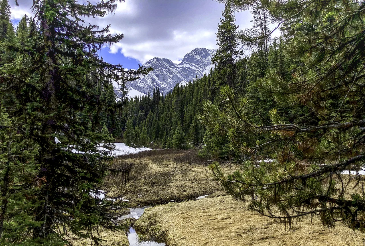
Rummel Lake Trail, Spray Valley Provincial Park
We managed to get in a hike that we were hoping to do late last week. The Rummel Lake Trail had a bear closure two days prior, then miraculously reopened. Splendid. It was raining the day of our hike, with about a 30% chance forecast throughout the day. We decided to take our chances, bundled up and headed out to Spray Lake Provincial Park. The rough, loose gravel road was blessedly clear of dust, settled from the rain. Our hike was about 9km (5.6mi) roundtrip, with a gradual elevation gain of about 427m (1,400 ft). It intersected with the High Rockies mountain bike trail and had a viewpoint overlooking the entire valley. The fall colors were just beginning, with the occasional lone aspen showing off it’s golden hue.
Spray Lake, from the bench on Rummel Lake Trail
About two-thirds of the way up, it started to drizzle. Then, it rained. Big, heavy, cold drops, freezing hands—you get the idea. The rain jackets came out, and we trudged up the trail, heads down, hoping the lake was just around the corner. Eventually it was, and it was spectacular.
Rummel Lake
Mt. Galatea
It was not conducive for peanut butter sandwiches, however. As Dave and I explored the trail up to a meadow, the rain stopped and the skies started to clear. Heading back, we took some additional photos of the lake, now sunny and as smooth as glass. The Spray Valley was dappled with sunlight.
Rummel Lake, after the rain
Rummel Lake
Towards the end of our adventure, we passed hikers in tank tops, who quizzically looked at us in our rain gear as if we were from another planet.
Post rain, Rummel Lake Trail
When I think back, what seemed really strange that day was that a half dozen spruce grouse were so busy feeding that they completely ignored us and wouldn’t give way of the trail.
Do they know something we don’t know?
What is the purpose of living in a beautiful place like Canmore if you can't share it with others?
This past summer was epic in terms of guests. Karen and Joe, Margaret, Curtis and Nancy, Bob and Suzanne, and Dad and Nona made the trip up to spend time in one of the most beautiful places in the world. We ran the visual gamut, from quintessential Lake Louise and Moraine Lake, to much smaller venues (which btw, were every bit as stunning) such as Wind Ridge Pass, Chester Lake, Grassi Lakes, and the Spray Lake Trail. K-Country provided a scenic drives with hikes around Upper Kananaskis Lake, as well as a trip to Rawson Lake.

From left: Karen, Dave and Joe on the bridge over Bow River, Canmore; Margaret lunching at Rawson Lake

Dave, Curtis and Nancy at Upper Kananaskis Lake, K-Country

Bob and Suzanne at Lake Louise, Banff National Park

Dad and Nona, Upper Kananaskis Lake, K-Country
But all in all, I have to admit that one of the best moments of the summer was when Dad joined us for the West Wind Pass hike. This hike is eight miles long, steep and arduous. Side note: Why is it, that I always seem to blank out the difficult parts of hikes? And, why is it that when we tell Nona we'll meet her for lunch, our escapades always seem to take the entire day? Thankfully, Dad was a true man of the mountains, steadily hiking upwards to scenery reminiscent of The Sound of Music. Oh, and did I mention that he is 85? What the hell were we thinking? Were we thinking?

Dad, on his way up to the pass.

Dad, Suzanne and Bob near the top.

Dave, Dad and I enjoying the view.
Was it worth it? You would have to ask my Dad. However, I think that the look of sheer delight on his face said it all. He crushed it.
As summer winds down, so do the fires. We have been blessed with clear skies and the opportunity to explore a bit more before we head south, like the geese. Memories of this summer have made me realize that sharing what we love with those we love is the gift that keeps on giving.
If at first you don’t succeed… After 80 busy signals, Dave broke through and secured a coveted 11km bus ride and a camping site for Lake O’Hara — the holy grail of the Canadian Rockies
“In this world of ours, the sparrow must live like a hawk if he is to fly at all”—Hayao Miyazaki
Well, then. That’s a tall order. I find similarities between that quote and hiking. If one never learns to climb, then one may never experience the view from the top. OK, let me put that in context. Once in a while, it is important to challenge yourself.
Moraine Lake is a Canadian treasure. Once seen, it is something you do not forget— it is visually stunning. It is also very, very difficult to visit. With only 125 parking spots and a slew of tour buses coming and going, the only real way to get there during the day is by shuttle. What if you are not a shuttle person? Well, if you are a tight schedule, and you really want to see the Moraine Lake, I suggest you become one.
Moraine Lake, sunset
In the past, we could get there by 8:30am and secure a parking space. Not this year. By 7am, the lot was full and the park had set up road blocks. So, we decided to visit after the shuttle service ended. The twilight would be amazing, the crowds diminished. Perfect. After all, it is a 90-minute drive to Lake Louise, so one had better have a plan.
The park website said the last shuttle was at 5:30pm. Great! We walked around Lake Louise (which was a wall of tourists) and then headed to Moraine Lake. Until we saw the BARRIERS. “The shuttles run until 7:30pm,” said a Parks employee. “You’ll have to come back then.” It was 6:30pm and we had an hour to kill. Now what?
killing time at Lake Louise Station
We drove to the ski lodge, which was closed. Hmmm. We looked for future hiking trails. We toured employee housing. And we visited the original Lake Louise train station, which was a worthwhile diversion.
An hour later, the barriers came down, and we were free to go—and WAIT. Parking slowly became available. By 8:30pm we were lakeside. The light on the mountains was god-like, and the lake a heavenly blue. Crowds dissipated. No tour buses.
Joe Farugia looking at Moraine Lake
Moraine Lake, Banff National Park
The future is upon us. Shuttles are becoming the only way to see the world’s treasures. And, it seems like there is no going back.

Canmore is known for its athletes, both professional and amateur. Everybody moves around here—climbing, biking, hiking, paddle-boarding. The love of sports is evident. Even so, the locals are always looking for new adventures. A recent tip from our neighbor led us to see the latest mountain trend. River surfing.
Canoe Meadows slalom course

Thumbs up, Tracy!
So, we took a drive to Canoe Meadows, which is located by the lower Kananaskis River in K Country. The parking lot was almost empty when we arrived at mid-morning. My guess is that surfers aren't necessarily early risers. Undaunted, we took a trail down to the river’s edge. This portion of the river was set up for canoe slalom. There were tons of gates, both red and green, positioned along the river amongst the rocks and rapids. Dave photographed a professional kayaker making her way through the course. Her name was Tracy Hines, and she was there for the ICF Kananaskis Canadian Nationals. She gave us some insight into the sport and what it entails, (besides a lot of strength). Think vectors.

Tracy Hines, Alabama, USA, testing the course.

We continued up the river to a deck that overlooked a large, standing wave. A lone surfer swam his way across the cold river and jumped up on his board. Regardless of location, it seems the ride often ends the same way. Wipeout.

For more information about river surfing in Alberta, visit https://albertariversurfing.com
Chester Lake was closed due to bear activity. Argh. Why didn’t we check the Park’s trail website before we left? Now what?
After an hour-long ride up Spray Lake Road, we were done with driving. What we needed was a Plan B. As luck would have it there was a B—as in Burstall Pass, just across the road. So, Plan B it was.
Mud Lake
The trail took us up an old logging road through forests and lakes to an alluvian meadow. Rivulets of water threaded throughout the terrain. as we made our way across the wet, muddy soil. Surrounded by mountains, we were captivated by Robertson Glacier as we tried in vain to keep our feet dry.
Alluvian meadow
Robertson Glacier
About 4 miles in we started our ascent. The dense forest trail opened up into an beautiful alpine meadow, filled with wildflowers and young spruce. I spotted a familiar track on the trail, which looked disturbingly kind of fresh. No worries, hahahaha. Ha, umm.
We hiked through patches of snow up to the headwall and were rewarded with mountain views in all directions. The expanse was humbling.
Windy and chilly, we tucked into a small island of trees to enjoy our sandwiches. Burstall Pass now ranks as one of our all-time favorite hikes. Not bad for a Plan B.
View from the pass.


