Viewing entries tagged
kananaskis country

Sparrowhawk Tarns

Comment

Sparrowhawk Tarns

At times, selective memory can come in handy. In hindsight, we, as humans, tend to block out certain realities while focusing on the overall experience. I find this selectiveness enormously helpful when revisiting a “favorite” hike.

I’m referring to Sparrowhawk Tarns—a relatively short (11.6km/ 7.2 mi) but steep (700m/2,283 ft) climb through a land of fossils and marmots—that takes you to a spectacular view of small lakes, meadows, and surrounding mountains.

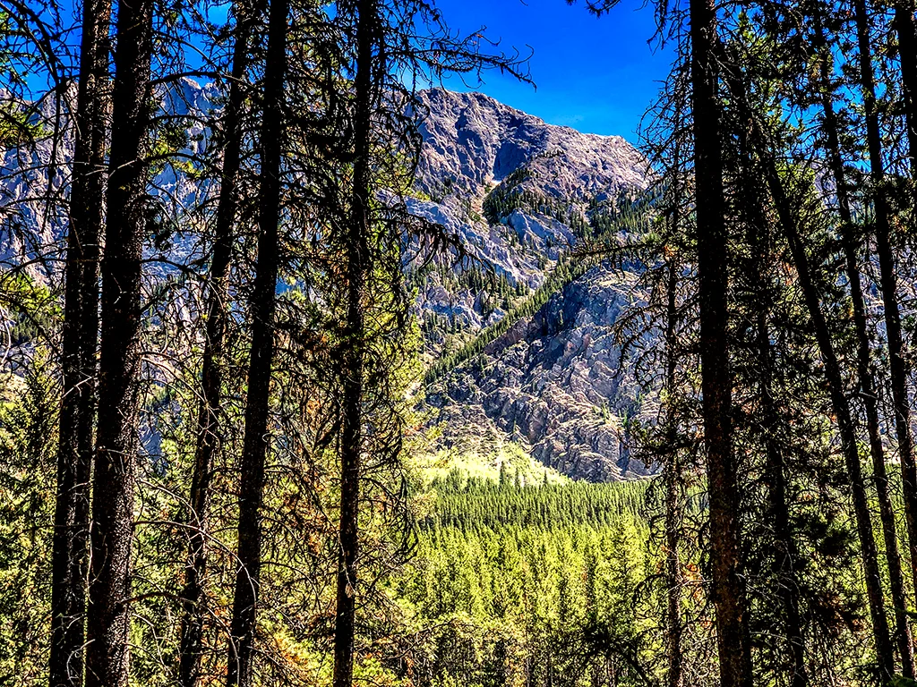
View of Sparrowhawk Mountain from the trail.

The day was ours to enjoy with turkey sandwiches, lots of water, and bug spray in tow. Our early start almost guaranteed minimal dust from Spray Lake Road—which came in handy for wildlife sightings.

The trail began on the High Rockies connector trail, leading to a junction for Sparrowhawk (left) and the High Rockies Trail (right).

High Rockies continues on right, Sparrowhawk straight ahead.

About 30 minutes into the hike, we heard a couple below us making their presence known to any bear within at least five miles (hahaha). Lo and behold—we know these people! What were the odds that we would run into our neighbors Corey and Willis on the same trail simultaneously? Pretty slim. Great minds think alike.

Willis and Corey with Maggie leading the way.

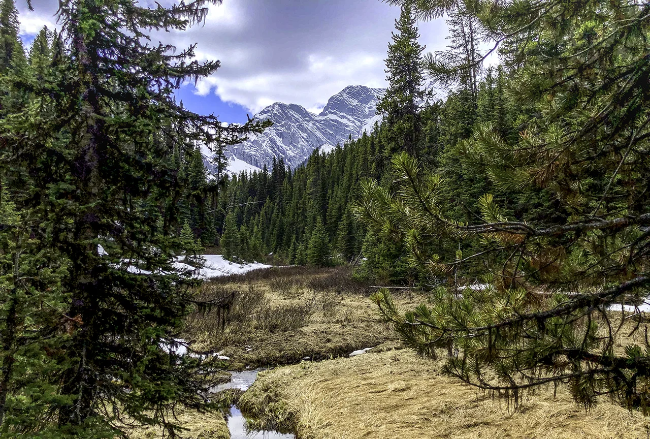
Excellent company and conversation took us past a lovely little stream, where Maggie took a quick dip.

We parted ways at the treeline—after taking a moment to photograph a nearby whistling marmot. 

Rocky climb begins here.

Marmot

Enter selective memory. Our climb involved a never-ending pile of boulders, following multiple paths leading to points unknown. Let’s say there are many ways to get to the top, and thankfully, the actual trail is much more apparent on the way down.

But the view is worth the effort. 

Alpine meadows.

Small lake view from our lunch site.

The trip back was steep, somewhat precarious, and not at all leisurely. Nonetheless, it was a heck of a lot faster than the climb. 

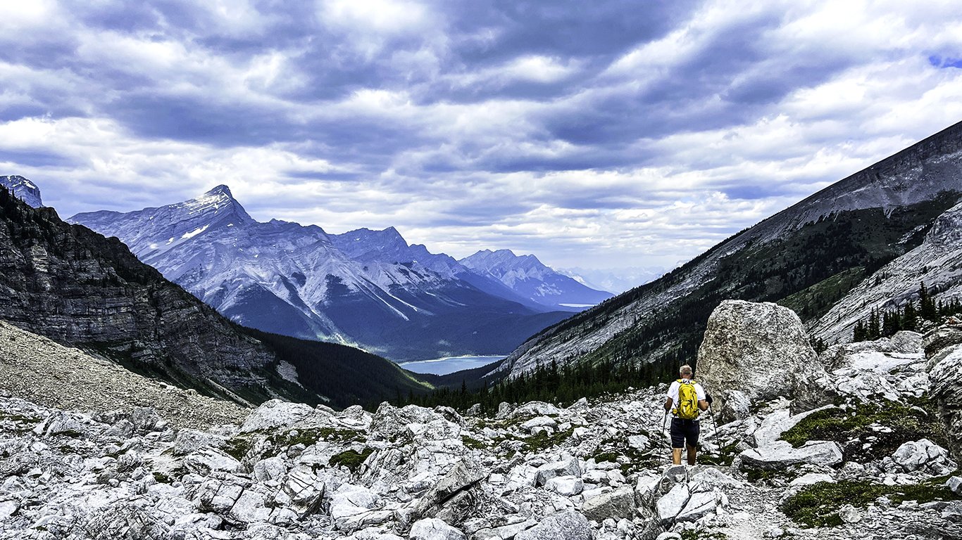
Dave making his way down, with Spray Lake in the distance.

Later that evening, Corey texted a photo she took of Maggie and Willis that captured the spirit of the day—serendipitous.

Maggie and Willis in the alpine meadow.


Comment

Ice is Nice

1 Comment

Ice is Nice

Labor Day is upon us along with, you guessed it, record heat. However, in Arizona, we’ve turned the corner—it’s September, and October is just within sight. Hallelujah.

1 Comment

Ptarmigan Cirque

1 Comment

Ptarmigan Cirque

This was our second attempt to hike Ptarmigan Cirque and I am thankful to report that this time, there was very little snow to contend with. After a cold, wet and rainy June, summer decided to finally appear for more than a day or two. The sun finally came out, and so did the people.

1 Comment

Summer Solstice

Comment

Summer Solstice

This year, the longest day was truly the longest day. Summer solstice sans summer. But the week of rain and high country snow eventually gave way to sunshine. And, the remaining stretch of Highway 40 in Kananaskis had opened, providing us with the opportunity to hike Ptarmigan Cirque.

It was spur of the moment. Dave and I hastily made a couple sandwiches, threw the bear spray in the Jeep and headed out. Little did we know what we would actually find.

On our way to the cirque!

On our way to the cirque!

IMG_4673.jpg

After a beautiful start up the mountain, we climbed into some thick clouds still remaining from the previous day’s rain. Fog as thick as peanut butter (hahahaha)—made it necessary to turn on fog lights and slow to a snail’s pace. What began as patchy snow became a blanket, reminiscent of early fall in the Rockies.

IMG_4678.jpg
DSC02290 copy.jpg

And then the sun broke through.

Just outside the parking lot at Ptarmigan Cirque Trail.

Just outside the parking lot at Ptarmigan Cirque Trail.

By the time we reached the cirque, it became apparent that there was to be no hiking today. The snow was close to a foot deep, and our boots were not waterproof.

Fresh snowfall.

Fresh snowfall.

IMG_4700 copy.jpg

You know, all in all, It didn't seem to matter. I had never seen the upper portion of the Kananaskis trail and it was quite magical.

DSC02320 copy.jpg

Ptarmigan Cirque can wait. :)


Comment

A Forest Walk

Comment

A Forest Walk

“We love the things we love for what they are.”  ― Robert Frost

Sometimes a hike is just a long walk in the woods. Many hikers tend to pass on hikes that don’t reward them with wide open spaces, memorable vistas and physical challenges. I get that. But sometimes, the solitude and quiet of a less travelled path can be quite lovely.

canmore june-hirez-edit-2.jpg

Pocaterra Trail was one of those paths. The trail is a gentle upward climb through the woods, with glimpses of creeks, small lakes and mountains. 

Pocaterra Creek.

Pocaterra Creek.

We were completely alone that morning. The forest floor was damp and soft from the recent snow. Our first detour was to Pocaterra Creek, which we accessed following a game trail. Still in search of that elusive moose…

canmore june-hirez-edit-6.jpg

A sea of fern appeared, captured in early morning sunlight. Another brief scramble took us down to Rockwall lake, it’s muddy bottom covered with elk tracks.

Rockwall Lake.

Rockwall Lake.

canmore june-hirez-edit-9.jpg

As we climbed up the ridge, the mountains came into view; below us, lush green meadows. 

DSC02218 copy.jpg

The trail was wide enough to walk side by side, and easy enough to hold a conversation. Dave and I solved many of the world’s problems that day (hahahaha). 

At one point we went off trail in search of Sparrow’s Lake. After foraging uphill through a mass of deadwood and moss we came upon a small meadow. A quick look at the map indicated that we would have to cross multiple ridges to get to the lake. That was not gonna happen. There was no real access from our route.

Strange and creepy mushrooms.

Strange and creepy mushrooms.

Oh—lest I forget, we saw some pretty weird mushrooms along the way, popping up under pine needles. I do not believe they are edible.

We were about three and half miles in when we realized our sandwiches were still on the counter at home. It was definitely time to head back.

canmore june-hirez-edit-11.jpg

Our favorite trails will open soon. The quiet and solitude will soon be replaced by an onslaught of tourists. But for a brief moment in early June, a quiet walk in the woods gave us both time to just be. 


Comment

Elk Pass

Comment

Elk Pass

Well, our first couple of weeks in Canmore have been interesting. Any schedule that previously existed was promptly thrown out the window. Especially at night. Luci took a few days to adjust to her new surroundings, and Dota is still adjusting to her new sister. It might take years. Everything around here happens at warp speed—until it doesn’t. Luci reminds me of the Honeybadger, a former LSU and Arizona Cardinal cornerback. She will knock off anything that gets in her way. She actually bounces. All kidding aside, Lucia is a welcome addition.

Sunday morning - before the hike.

Sunday morning - before the hike.

With that said, Dave and I left the pups and ventured out for our first hike last week. Elk Pass to Frozen Lake is an 8.4 mile out and back trail located by Lower Kananaskis Lake. The trail, an old fire road, eventually leads to Elk Lakes Cabin (maintained by the Alpine Club of Canada) and a backcountry campground. 

IMG_4408-2.jpg

It was about an hours drive from our place to the trailhead. The weather was cloudy and a chilly 45°. Our trek started off blissfully snow-free and dry. However, as we gained elevation, the dry trail turned to ice and snow—slowing our pace considerably.

What happened to the trail?

What happened to the trail?

Fox Creek. No sign of moose.

Fox Creek. No sign of moose.

We crossed multiple bridges, following some giant moose tracks in hopes of a sighting.

IMG_4418 copy.jpg

The Kananaskis range is daunting and massive. There were some impressive views to be had along the way. 

Icy meadow. No sign of moose.

Icy meadow. No sign of moose.

As the day progressed, the snow turned into slush. By the time we reached the meadow, it was a real mud-fest. We were about 3.5 miles in when we decided to have a bite to eat and head back. 

Wildflowers blooming out of the bog.

Wildflowers blooming out of the bog.

Tired and cold, we were still content. For the first hike of the season, it was a splendid way to get our feet (soaking) wet.


Comment

Sea of Humanity

Sea of Humanity

Moraine Lake is a Canadian treasure. Once seen, it is something you do not forget— it is visually stunning. It is also very, very difficult to visit. With only 125 parking spots and a slew of tour buses coming and going, the only real way to get there during the day is by shuttle. What if you are not a shuttle person? Well, if you are a tight schedule, and you really want to see the Moraine Lake, I suggest you become one. 

Moraine Lake, sunset

In the past, we could get there by 8:30am and secure a parking space. Not this year. By 7am, the lot was full and the park had set up road blocks. So, we decided to visit after the shuttle service ended. The twilight would be amazing, the crowds diminished. Perfect. After all, it is a 90-minute drive to Lake Louise, so one had better have a plan. 

The park website said the last shuttle was at 5:30pm. Great!  We walked around Lake Louise (which was a wall of tourists) and then headed to Moraine Lake. Until we saw the BARRIERS.  “The shuttles run until 7:30pm,” said a Parks employee. “You’ll have to come back then.” It was 6:30pm and we had an hour to kill. Now what?

killing time at Lake Louise Station

We drove to the ski lodge, which was closed. Hmmm. We looked for future hiking trails. We toured employee housing. And we visited the original Lake Louise train station, which was a worthwhile diversion.

An hour later, the barriers came down, and we were free to go—and WAIT. Parking slowly became available. By 8:30pm we were lakeside. The light on the mountains was god-like, and the lake a heavenly blue. Crowds dissipated. No tour buses.

Joe Farugia looking at Moraine Lake

Moraine Lake, Banff National Park

The future is upon us. Shuttles are becoming the only way to see the world’s treasures. And, it seems like there is no going back.


Surfs Up

Surfs Up

edit_blg-1-5.jpg

Canmore is known for its athletes, both professional and amateur. Everybody moves around here—climbing, biking, hiking, paddle-boarding. The love of sports is evident. Even so, the locals are always looking for new adventures. A recent tip from our neighbor led us to see the latest mountain trend. River surfing.

Canoe Meadows slalom course

Thumbs up, Tracy!

Thumbs up, Tracy!

So, we took a drive to Canoe Meadows, which is located by the lower Kananaskis River in K Country. The parking lot was almost empty when we arrived at mid-morning. My guess is that surfers aren't necessarily early risers. Undaunted, we took a trail down to the river’s edge. This portion of the river was set up for canoe slalom. There were tons of gates, both red and green, positioned along the river amongst the rocks and rapids. Dave photographed a professional kayaker making her way through the course. Her name was Tracy Hines, and she was there for the ICF Kananaskis Canadian Nationals. She gave us some insight into the sport and what it entails, (besides a lot of strength). Think vectors.

Tracy Hines, Alabama, USA, testing the course.

Tracy Hines, Alabama, USA, testing the course.

edit_blg-1542-2.jpg

We continued up the river to a deck that overlooked a large, standing wave. A lone surfer swam his way across the cold river and jumped up on his board. Regardless of location, it seems the ride often ends the same way. Wipeout.

edit_blg-1-4.jpg

For more information about river surfing in Alberta, visit https://albertariversurfing.com